
 for ArcGIS
![]() Telemorphic
is proud to announce that MultiViewer has received the Frost and
Sullivan GeoTechnologies Customer Value Enhancement award!
(pdf)
Telemorphic
is proud to announce that MultiViewer has received the Frost and
Sullivan GeoTechnologies Customer Value Enhancement award!
(pdf)
MultiViewer™ for ArcGIS™ extends powerful linked map viewer functionality to ArcGIS, enabling a user to simultaneously visualize up to five map views in geospatial context. Great for visual comparison of imagery with other data layers such as thematic maps, GIS vectors, scanned topo maps, DEMs, or historical maps! Advanced geospatial visualization capabilities that compliment most ArcGIS-based solutions.
MultiViewer™ works with any geospatial data that can be ingested and displayed within the ArcGIS environment, regardless of where the data resides (local disk, enterprise geodatabase, or web map services).
San Francisco, CA
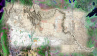
Juxtaposing maps from different eras...

Click
on the image for more detail - hi-res version will show
in a new window
Data
shown is from the Rumsey
Collection, San Francisco
Baghdad
Comparing different types of data...

Click
on the image for more detail - hi-res version will show
in a new window
Data
shown is from Telemorphic, Inc., Baghdad