
Earth Sciences and Education
CalView — Satellite Imagery Visualization & Analysis System for the State of California
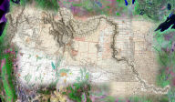
 Aerial
images of California are useful for a variety of tasks ranging
from managing wildfires and urban growth to monitoring streams,
estuaries, and air. Professionals trained in GIS (Geographic Information
Systems) and RS (Remote Sensing) use aerial imagery on a daily
basis to solve challenges facing society. Until recently, this
typically required complex and expensive GIS/image analysis software,
and high-end desktop workstations, greatly limiting public access
to this valuable geographic resource. CalView makes working with
geographic information easy and fun for everyone. CalView uses
Maplicity and MapImager, the ground-breaking web geospatial visualization
& analysis tools from Telemorphic, Inc., to provide affordable
on-line public access to RS/GIS tools and extensive archives of
imagery through the California Spatial Information Library (CaSIL).
CalView is California's implementation of AmericaView, a partnership
between the US Geological Survey and the AmericaView Consortium.
The California Resources Agency, National Aeronautics and Space
Administration (NASA), and CalSpace at University of California
- Davis, are working together to bring images from space into
classrooms and workplaces around the state.
Aerial
images of California are useful for a variety of tasks ranging
from managing wildfires and urban growth to monitoring streams,
estuaries, and air. Professionals trained in GIS (Geographic Information
Systems) and RS (Remote Sensing) use aerial imagery on a daily
basis to solve challenges facing society. Until recently, this
typically required complex and expensive GIS/image analysis software,
and high-end desktop workstations, greatly limiting public access
to this valuable geographic resource. CalView makes working with
geographic information easy and fun for everyone. CalView uses
Maplicity and MapImager, the ground-breaking web geospatial visualization
& analysis tools from Telemorphic, Inc., to provide affordable
on-line public access to RS/GIS tools and extensive archives of
imagery through the California Spatial Information Library (CaSIL).
CalView is California's implementation of AmericaView, a partnership
between the US Geological Survey and the AmericaView Consortium.
The California Resources Agency, National Aeronautics and Space
Administration (NASA), and CalSpace at University of California
- Davis, are working together to bring images from space into
classrooms and workplaces around the state.
The Planetary Interactive GIS on-the-Web Analyzable Database (PIGWAD) for USGS and NASA
 NASA's
recent successes in space exploration have resulted in immense archives
of imagery and mapping data about neighboring planets in our solar
system. Most notably, the Mars rover delivered stunning views of
a very small portion of the surface of the planet, re-igniting public
interest and enthusiasm in space exploration. Other systems, such
as the Mars orbiter, have mapped the entire surface of the red planet,
as well as other extraterrestrial bodies including Earth's Moon,
Venus, and even portions of Jupiter's moons Europa, Io, and Ganymeade.
USGS' Planetary Interactive GIS on-the-Web Analyzable Database (PIGWAD)
supports research by scientists around the world, as well as practical
on-line public access to this remarkable planetary spatial database
AND the GIS/geospatial visualization tools necessary to make use
of the data. PIGWAD's Internet GIS implementation is unique in that
it provides optional GIS and image analysis/visualization interfaces
depending on the specific user's Internet connectivity and level
of mapping/GIS experience (Beginner, Intermediate, or Advanced GIS).
PIGWAD uses Telemorphic's Maplicity™ as their Advanced GIS for the
web.
NASA's
recent successes in space exploration have resulted in immense archives
of imagery and mapping data about neighboring planets in our solar
system. Most notably, the Mars rover delivered stunning views of
a very small portion of the surface of the planet, re-igniting public
interest and enthusiasm in space exploration. Other systems, such
as the Mars orbiter, have mapped the entire surface of the red planet,
as well as other extraterrestrial bodies including Earth's Moon,
Venus, and even portions of Jupiter's moons Europa, Io, and Ganymeade.
USGS' Planetary Interactive GIS on-the-Web Analyzable Database (PIGWAD)
supports research by scientists around the world, as well as practical
on-line public access to this remarkable planetary spatial database
AND the GIS/geospatial visualization tools necessary to make use
of the data. PIGWAD's Internet GIS implementation is unique in that
it provides optional GIS and image analysis/visualization interfaces
depending on the specific user's Internet connectivity and level
of mapping/GIS experience (Beginner, Intermediate, or Advanced GIS).
PIGWAD uses Telemorphic's Maplicity™ as their Advanced GIS for the
web.
USGS Maps-On-Line - Interactive Maps for the Greater San Francisco Bay Area
 The
USGS Western Geographic Science Centers "Maps-On-Line" provides
public access to web based maps and GIS tools for the San Francisco
Bay Area Regional Database (BARD), a seamless baseline of maps
and imagery including topographic maps, aerial photos, and satellite
imagery for the ten county San Francisco Bay Area, one of the
largest metro areas on the West coast. Powered by Telemorphic's
Java-based Maplicity and ESRI's ArcIMS, USGS Maps-On-Line was
the first public access Internet mapping site to provide web browser-based
users with geospatial content AND the interactive GIS and imagery
visualization/analysis tools required to make use of the content.
Such broad web accessibility to maps & tools introduce geospatial
technologies to a much larger audience. Telemorphic also provides public access to an enhanced version of
USGS BARD, which includes historical maps and aerial photos,
vector GIS overlays, expanded satellite imagery archives, and
additional on-line viewing options/tools available to web browser
users based on their level of experience and Internet connectivity.
The
USGS Western Geographic Science Centers "Maps-On-Line" provides
public access to web based maps and GIS tools for the San Francisco
Bay Area Regional Database (BARD), a seamless baseline of maps
and imagery including topographic maps, aerial photos, and satellite
imagery for the ten county San Francisco Bay Area, one of the
largest metro areas on the West coast. Powered by Telemorphic's
Java-based Maplicity and ESRI's ArcIMS, USGS Maps-On-Line was
the first public access Internet mapping site to provide web browser-based
users with geospatial content AND the interactive GIS and imagery
visualization/analysis tools required to make use of the content.
Such broad web accessibility to maps & tools introduce geospatial
technologies to a much larger audience. Telemorphic also provides public access to an enhanced version of
USGS BARD, which includes historical maps and aerial photos,
vector GIS overlays, expanded satellite imagery archives, and
additional on-line viewing options/tools available to web browser
users based on their level of experience and Internet connectivity.