
Museums & Libraries
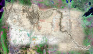
The David Rumsey Map Collection Web GIS and Geospatial Visualization System
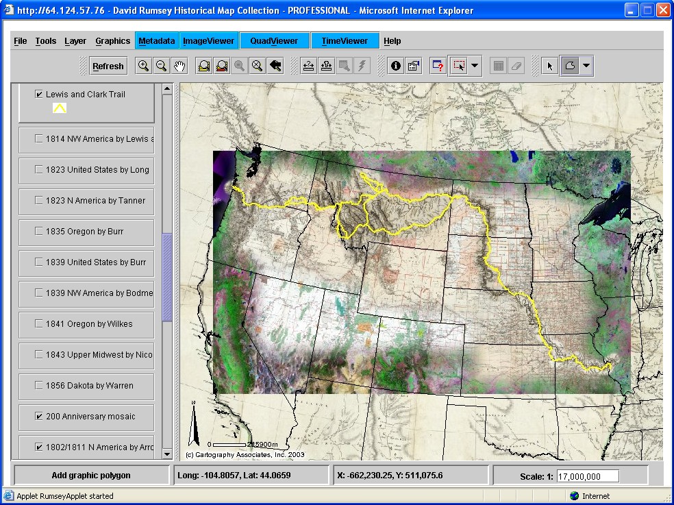 With
over 150,000 works, the David Rumsey Collection is one of the
world's largest private collections of 19th and early 20th century
maps. Approximately 10,000 of these maps have been digitized and
made available for public access on the Web. These maps have enormous
potential to improve our understanding of historical trends in
land use and development, the dynamics of landscape change, and
mankind's impact on the environment over hundreds of years. David
Rumsey realized the hidden value of his historical maps, and contacted
Telemorphic to help him and visitors to his website visualize
historical and modern maps. Telemorphic provided the complete
turnkey solution for web GIS and geospatial visualization, including
historical + modern geospatial database development, Internet
GIS administration and hosting, and custom application development
building upon Maplicity's robust client-side visualization capabilities
and ArcIMS' server-side GIS technology. The result is a lightweight
(350kb) GIS Browser enabling on-line visitors to the David Rumsey
Collection to interactively compare maps and imagery from past
and present, as well as a variety of advanced map creation, GIS,
and image analysis/visualization functionality. The solution currently
includes comprehensive geospatial content for ten (10) regions
including San Francisco, Boston, New York, Washington, Chicago,
the Lewis & Clark Expedition, Mt. Washington, NV, and Tokyo, Kyoto,
and Osaka, Japan. It is widely recognized as one of the most compelling
mapping/GIS applications on the Internet, and has received numerous
awards and recognition including the prestigious International
Academy of Digital Arts and Sciences' "Webby Award"for best technical
innovation, and "Best Internet Application"at ESRI's International
User Conference. [Live Demo].
With
over 150,000 works, the David Rumsey Collection is one of the
world's largest private collections of 19th and early 20th century
maps. Approximately 10,000 of these maps have been digitized and
made available for public access on the Web. These maps have enormous
potential to improve our understanding of historical trends in
land use and development, the dynamics of landscape change, and
mankind's impact on the environment over hundreds of years. David
Rumsey realized the hidden value of his historical maps, and contacted
Telemorphic to help him and visitors to his website visualize
historical and modern maps. Telemorphic provided the complete
turnkey solution for web GIS and geospatial visualization, including
historical + modern geospatial database development, Internet
GIS administration and hosting, and custom application development
building upon Maplicity's robust client-side visualization capabilities
and ArcIMS' server-side GIS technology. The result is a lightweight
(350kb) GIS Browser enabling on-line visitors to the David Rumsey
Collection to interactively compare maps and imagery from past
and present, as well as a variety of advanced map creation, GIS,
and image analysis/visualization functionality. The solution currently
includes comprehensive geospatial content for ten (10) regions
including San Francisco, Boston, New York, Washington, Chicago,
the Lewis & Clark Expedition, Mt. Washington, NV, and Tokyo, Kyoto,
and Osaka, Japan. It is widely recognized as one of the most compelling
mapping/GIS applications on the Internet, and has received numerous
awards and recognition including the prestigious International
Academy of Digital Arts and Sciences' "Webby Award"for best technical
innovation, and "Best Internet Application"at ESRI's International
User Conference. [Live Demo].
Yale University's Historical New Haven Digital Collection
 Yale
University's Historical Digital Collection contains over 500 images
of historical New Haven, as well as over 75 documents containing
key census information, maps, and other data from New Haven over
the past 150 years. An extensive map section on the website allows
web browser users to interactively compare multiple maps of New
Haven from different time periods at the block and even building
level. The website also allows visitors to locate addresses and
major features like churches and local parks, as well as create
and print custom map compositions. The project is part of the
Electronic Library Initiatives (ELI) program, a focused effort
by Yale University Libraries to facilitate and study the use of
digital images and other materials in teaching, learning, and
scholarship. The on-line mapping and GIS resource supports the
university's educational and research programs related to history,
planning, and urban development. The site is powered by Telemorphic's
Maplicity and ESRI's ArcIMS.
Yale
University's Historical Digital Collection contains over 500 images
of historical New Haven, as well as over 75 documents containing
key census information, maps, and other data from New Haven over
the past 150 years. An extensive map section on the website allows
web browser users to interactively compare multiple maps of New
Haven from different time periods at the block and even building
level. The website also allows visitors to locate addresses and
major features like churches and local parks, as well as create
and print custom map compositions. The project is part of the
Electronic Library Initiatives (ELI) program, a focused effort
by Yale University Libraries to facilitate and study the use of
digital images and other materials in teaching, learning, and
scholarship. The on-line mapping and GIS resource supports the
university's educational and research programs related to history,
planning, and urban development. The site is powered by Telemorphic's
Maplicity and ESRI's ArcIMS.