
Real Estate Information Services
Interactive Aerial Imagery Comparison Tools
for
GlobeXplorer, LLC.
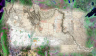
 Satellite
imagery and aerial photography offer real estate professionals
additional sources of information about property that can improve
their business processes. Current overhead imagery can reveal
local landscape and neighborhood dynamics not depicted on conventional
maps, MLS property listings, or even during on-site visits to
properties. Historical imagery also provides insights into what
was there before, which is of particular interest related to commercial
real estate transactions and identification of potential liability
concerns. GlobeXplorer, a subsidiary of Stewart Information Services
Corporation (NYSE-STC), is the leading on-line provider of satellite
and aerial imagery for the real estate information services industry
(as well as other markets). GlobeXplorer uses MapImager™ (by Telemorphic)
to make it fast and easy for their ImageConnect customers to conduct
interactive comparisons of multiple dates of satellite imagery,
aerial photos, and maps in the popular ESRI desktop mapping/GIS
environment. Read more
Satellite
imagery and aerial photography offer real estate professionals
additional sources of information about property that can improve
their business processes. Current overhead imagery can reveal
local landscape and neighborhood dynamics not depicted on conventional
maps, MLS property listings, or even during on-site visits to
properties. Historical imagery also provides insights into what
was there before, which is of particular interest related to commercial
real estate transactions and identification of potential liability
concerns. GlobeXplorer, a subsidiary of Stewart Information Services
Corporation (NYSE-STC), is the leading on-line provider of satellite
and aerial imagery for the real estate information services industry
(as well as other markets). GlobeXplorer uses MapImager™ (by Telemorphic)
to make it fast and easy for their ImageConnect customers to conduct
interactive comparisons of multiple dates of satellite imagery,
aerial photos, and maps in the popular ESRI desktop mapping/GIS
environment. Read more
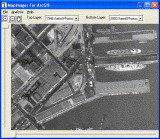
On-Line Aerial Studio for Landiscor Aerial Information, Inc.
 Detailed,
up-to-date aerial imagery is of considerable value to real estate
professionals, land developers, and planners. Landiscor, a leading
provider of aerial imagery, required a web based system that allowed
its sales staff, as well as end customers, to quickly and easily
access the company's vast archives of imagery and other map information
in order to create custom maps for regions of interest, potential
development sites, etc. Telemorphic leveraged it's MaplicitySDK
to create Landiscor's Aerial Studio, a custom Maplicity-based
solution that addressed their specific business requirements for
on-line geospatial technology. Aerial Studio is a lightweight
(450kb) applet that communicates with Pixxures' WebPix image server
technology. Aerial Studio provides any web browser user with access
to Landiscor's massive archives of multi-date high resolution
imagery, as well as nationwide coverage for other imagery and
map archives such as those from the federal government (USGS)
and commercial geospatial web services (ArcWeb Services). Aerial
Studio allows the on-line user to create and order their own custom
image prints in a matter of minutes, complete with interactive,
user-defined graphics, text labels, notes, logos, digital photos,
and more. It also includes basic GIS tools such as navigation/search,
measure distance, measure area, and buffer. The user can then
save the custom maps for future editing, and/or place an order
for large format prints or high resolution download of the digital
files within minutes. Aerial Studio was fully integrated into
Landiscor's eNavigator on-line fulfillment and e-commerce system.
Previously, such custom map orders required specialized desktop
GIS software and training, as well as extensive consultation with
a Landiscor customer service representative. As a result, Landiscor
greatly reduced it costs of fulfillment, while at the same time
expanding it potential customer base to anyone with web access.
Detailed,
up-to-date aerial imagery is of considerable value to real estate
professionals, land developers, and planners. Landiscor, a leading
provider of aerial imagery, required a web based system that allowed
its sales staff, as well as end customers, to quickly and easily
access the company's vast archives of imagery and other map information
in order to create custom maps for regions of interest, potential
development sites, etc. Telemorphic leveraged it's MaplicitySDK
to create Landiscor's Aerial Studio, a custom Maplicity-based
solution that addressed their specific business requirements for
on-line geospatial technology. Aerial Studio is a lightweight
(450kb) applet that communicates with Pixxures' WebPix image server
technology. Aerial Studio provides any web browser user with access
to Landiscor's massive archives of multi-date high resolution
imagery, as well as nationwide coverage for other imagery and
map archives such as those from the federal government (USGS)
and commercial geospatial web services (ArcWeb Services). Aerial
Studio allows the on-line user to create and order their own custom
image prints in a matter of minutes, complete with interactive,
user-defined graphics, text labels, notes, logos, digital photos,
and more. It also includes basic GIS tools such as navigation/search,
measure distance, measure area, and buffer. The user can then
save the custom maps for future editing, and/or place an order
for large format prints or high resolution download of the digital
files within minutes. Aerial Studio was fully integrated into
Landiscor's eNavigator on-line fulfillment and e-commerce system.
Previously, such custom map orders required specialized desktop
GIS software and training, as well as extensive consultation with
a Landiscor customer service representative. As a result, Landiscor
greatly reduced it costs of fulfillment, while at the same time
expanding it potential customer base to anyone with web access.