Lewis & Clark Prints
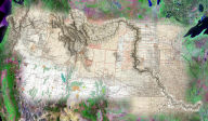
Back by popular demand, with the kind permission of David Rumsey and with the able assistance of Pictopia, we bring to you the award-winning Lewis & Clark Mosaic.
 A
mosaic of 4 different images: a backdrop of 1990's Landsat
imagery with USGS 1970 National Atlas, overlaid with
1879 & 1867 US General Land Office maps, finally
topped with the 1814 Lewis map from the Rumsey archives.
The print is available in 5 different sizes:
Price |
|||||
17 |
x |
11 |
$ |
35.00 |
|
28 |
x |
16.33 |
$ |
99.00 |
|
36 |
x |
21 |
$ |
175.00 |
|
54 |
x |
31.5 |
$ |
250.00 |
|
72 |
x |
42 |
$ |
350.00 |
Each print comes with an index map - a smaller image with a description of the process and the images used to create the mosaic.

