
 for ArcGIS™
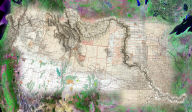
MapImager™ adds simple, easy-to-use image analysis and visualization tools to ESRI's ArcGIS. MapImager allows you to quickly perform powerful interactive image or map comparisons within the familiar ArcMap™ environment. With one button you can toggle between blend, swipe, change bands, and custom morphing controls.
MapImager also adds the ability to create, save and/or download customized images from various sources, and integrate these images directly within your ArcMap document. MapImager for ArcGIS works equally well with vectors, digital imagery, aerial photos, and scanned maps.
| Swipe | Blend |
|---|---|
 |
 |
| Morph | Change Bands |
 |
 |
| Click on the images for an animated demo | |