
Defense and Intelligence
GeoServer® — Net-Centric System for Geospatial Dissemination and Exploitation
 Defense
and Intelligence mission requirements demand instant access to
geospatial information by distributed teams of resource managers,
intel analysts, field operatives, and warfighters...anytime, anywhere.
GeoServer®, by Photon Research Associates (PRA) provides the solution.
GeoServer® is a web centric system used to broker, archive, discover,
exploit and disseminate geospatial information and analysis tools,
`using a scalable client-server model to provide instant access
to integrated raster and vector geospatial data using a browser
interface. PRA's engineering and software development team were
able to quickly and easily create GeoServer using MaplicitySDK™,
Telemorphic's complete Java API for developing lightweight yet
powerful net-centric geospatial solutions. GeoServer
Brochure (PDF)
Defense
and Intelligence mission requirements demand instant access to
geospatial information by distributed teams of resource managers,
intel analysts, field operatives, and warfighters...anytime, anywhere.
GeoServer®, by Photon Research Associates (PRA) provides the solution.
GeoServer® is a web centric system used to broker, archive, discover,
exploit and disseminate geospatial information and analysis tools,
`using a scalable client-server model to provide instant access
to integrated raster and vector geospatial data using a browser
interface. PRA's engineering and software development team were
able to quickly and easily create GeoServer using MaplicitySDK™,
Telemorphic's complete Java API for developing lightweight yet
powerful net-centric geospatial solutions. GeoServer
Brochure (PDF)
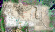
Web GIS & Satellite Image Visualization System for the Middle East, Iraq, Afghanistan, and Pakistan
 The Web GIS & Satellite Image Visualization
System, created and hosted by Telemorphic, provides web based
public access to declassified U.S Government maps and imagery
for the Middle East, Iraq, Afghanistan, and Pakistan, delivered
complete with easy-to-use, lightweight, yet powerful image exploitation
and GIS functionality. While Defense & Intelligence Community
"end customers" (typically warfighters and field operatives) in
theory have 24/7/365 access to these maps and imagery through
official government channels, this doesn't always happen in the
"real-world" due to chain-of-command & bureaucracy issues (red
tape), as well as legitimate security concerns or IT/system admin
restrictions. Nor does such data access always include the web
tools to make effective use of the maps & imagery. The Maplicity-powered
system includes simple web tools enabling fast navigation of seamless
imagery and vector data, interactive image visualizations and
GIS analyses, and map or image redlining/markup to create, download,
print, and/or share custom maps. Originally intended simply as
a demo of Maplicity, Telemorphic's commercial off-the-shelf software
for supporting net-centric geospatial intelligence, this high
interest public access system supports thousands of users in defense
& intelligence.
The Web GIS & Satellite Image Visualization
System, created and hosted by Telemorphic, provides web based
public access to declassified U.S Government maps and imagery
for the Middle East, Iraq, Afghanistan, and Pakistan, delivered
complete with easy-to-use, lightweight, yet powerful image exploitation
and GIS functionality. While Defense & Intelligence Community
"end customers" (typically warfighters and field operatives) in
theory have 24/7/365 access to these maps and imagery through
official government channels, this doesn't always happen in the
"real-world" due to chain-of-command & bureaucracy issues (red
tape), as well as legitimate security concerns or IT/system admin
restrictions. Nor does such data access always include the web
tools to make effective use of the maps & imagery. The Maplicity-powered
system includes simple web tools enabling fast navigation of seamless
imagery and vector data, interactive image visualizations and
GIS analyses, and map or image redlining/markup to create, download,
print, and/or share custom maps. Originally intended simply as
a demo of Maplicity, Telemorphic's commercial off-the-shelf software
for supporting net-centric geospatial intelligence, this high
interest public access system supports thousands of users in defense
& intelligence.
Nellis Air Force Base Environmental Management
Application
for EcoLogic Systems
 Occupational
health and safety at military facilities is an important element
of long term continuity of operations and mission readiness at
the U.S Department of Defense (DoD). Ecologic Systems' ADAM environmental
management software helps military bases (as well as property
management firms, school districts, colleges, and corporations)
manage all of their facilities' asbestos, lead paint, and Indoor
Air Quality (IAQ) information and thereby comply with DoD, EPA
and OSHA requirements. Nellis Air Force Base (AFB) has an accurate
and comprehensive Enterprise Geographic Information System (GIS)
resulting from the USAF's GeoBase program. Telemorphic's MaplicityJSP
was used to seamlessly integrate GeoBase and ADAM to allow Nellis
AFB's facility management and regulatory personnel to generate
interactive maps, custom queries, and on-demand reports related
to asbestos, lead paint, and air quality via an easy-to-use web
browser map interface.
Occupational
health and safety at military facilities is an important element
of long term continuity of operations and mission readiness at
the U.S Department of Defense (DoD). Ecologic Systems' ADAM environmental
management software helps military bases (as well as property
management firms, school districts, colleges, and corporations)
manage all of their facilities' asbestos, lead paint, and Indoor
Air Quality (IAQ) information and thereby comply with DoD, EPA
and OSHA requirements. Nellis Air Force Base (AFB) has an accurate
and comprehensive Enterprise Geographic Information System (GIS)
resulting from the USAF's GeoBase program. Telemorphic's MaplicityJSP
was used to seamlessly integrate GeoBase and ADAM to allow Nellis
AFB's facility management and regulatory personnel to generate
interactive maps, custom queries, and on-demand reports related
to asbestos, lead paint, and air quality via an easy-to-use web
browser map interface.
Innovative Geospatial Tools for the Defense/Intel Community
 There
are literally hundreds of geospatial software tools available
to the various U.S. Government agencies that make up the Defense
and Intelligence Community. Telemorphic's customers in this space
include the Central Intelligence Agency (CIA), the Defense Intelligence
Agency (DIA), the National Geospatial-Intelligence Agency (NGA),
and others.
There
are literally hundreds of geospatial software tools available
to the various U.S. Government agencies that make up the Defense
and Intelligence Community. Telemorphic's customers in this space
include the Central Intelligence Agency (CIA), the Defense Intelligence
Agency (DIA), the National Geospatial-Intelligence Agency (NGA),
and others.
So what sets our software apart from the plethora of tools available to these customers?
- Ease of Use - Why waste intel analysts' time for specialized software training?
- Simple to Install - "The easiest software we ever installed!" [CIA customer]
- Interoperable - Works with what they already have...why reinvent the wheel?
- High Speed, Low Drag - Fast & interactive to support real-time decisions.
- Collaborative, Net-Centric - Works well with web distributed teams of analysts - anytime, anywhere.
- Revolutionary Innovation - "I didn't think that was possible" and "we could really use that" are comments we hear all the time. Our tools live "outside the box."
- Experience - We are former military and GIS/image analysts with a strong understanding of what the mission requires. When it comes to geospatial technologies, we are the tip of the spear!