
Homeland Security
RadNet: A Mobile Distributed Radiation Threat Monitoring Network for Lawrence Livermore National Laboratory (LLNL)
 The
threat of nuclear terrorism presents one of the most complex challenges
to federal, state, and local government agencies responsible for
Homeland Security. While the possibility of a "dirty bomb" is
chilling, imagine the "silent bomb" scenario: Lethal concentrations
of illicit radioactive material are placed in densely populated
buildings or mass transit locations without any explosion. Weeks
later, hospitals begin to report the effects of mass radiation
poisoning, but by then it is too late for thousands of people.
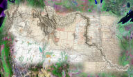
Lawrence Livermore National Laboratory prototyped RadNet to aid
in countering this threat. RadNet is a network of GPS enabled
mobile devices (cell phone + PDA) fitted with gamma radiation
detectors. The devices collect radiation readings and locations
at fixed time intervals, and establish wireless connections for
transmitting the data to a server based Internet Geographic Information
System (GIS), which then stores, manages, and analyzes the data
to generate "hot spot" maps depicting locations of increased radioactivity.
The maps can then be quickly delivered on-line to first responders.
The GIS for RadNet consists of Telemorphic's Maplicity integrated
with MapServer, PostGIS, PostgreSQL
The
threat of nuclear terrorism presents one of the most complex challenges
to federal, state, and local government agencies responsible for
Homeland Security. While the possibility of a "dirty bomb" is
chilling, imagine the "silent bomb" scenario: Lethal concentrations
of illicit radioactive material are placed in densely populated
buildings or mass transit locations without any explosion. Weeks
later, hospitals begin to report the effects of mass radiation
poisoning, but by then it is too late for thousands of people.
Lawrence Livermore National Laboratory prototyped RadNet to aid
in countering this threat. RadNet is a network of GPS enabled
mobile devices (cell phone + PDA) fitted with gamma radiation
detectors. The devices collect radiation readings and locations
at fixed time intervals, and establish wireless connections for
transmitting the data to a server based Internet Geographic Information
System (GIS), which then stores, manages, and analyzes the data
to generate "hot spot" maps depicting locations of increased radioactivity.
The maps can then be quickly delivered on-line to first responders.
The GIS for RadNet consists of Telemorphic's Maplicity integrated
with MapServer, PostGIS, PostgreSQL
Enterprise Knowledge Discovery, Management, and Sharing
 The
Homeland Defense and Security mission requires rapid discovery
and sharing of relevant multi-source information across responsible
federal, state, and local government agencies and departments.
Global InfoTek Inc. (GITI) develops advanced solutions in knowledge
discovery and collaborative knowledge management. GITI's Verona™ is a powerful collaborative knowledge management tool that can
be used to harness, organize, present, share, and distribute corporate
knowledge throughout/across organizations involved in homeland
defense using a web browser-based electronic notebook. LumINT™ is GITI's Knowledge Discovery Toolkit which enables enterprise-wide
knowledge discovery services in homeland security, law enforcement,
defense, and intelligence delivered via the Internet, intranet,
and/or secure networks. Telemorphic's Maplicity is a key component
of these solutions, providing powerful geospatial information
discovery and interactive imagery exploitation, mapping, and GIS
functionality in a highly portable, lightweight (350kb), and dynamic
plug-n-play web environment. Read
more (PDF)
The
Homeland Defense and Security mission requires rapid discovery
and sharing of relevant multi-source information across responsible
federal, state, and local government agencies and departments.
Global InfoTek Inc. (GITI) develops advanced solutions in knowledge
discovery and collaborative knowledge management. GITI's Verona™ is a powerful collaborative knowledge management tool that can
be used to harness, organize, present, share, and distribute corporate
knowledge throughout/across organizations involved in homeland
defense using a web browser-based electronic notebook. LumINT™ is GITI's Knowledge Discovery Toolkit which enables enterprise-wide
knowledge discovery services in homeland security, law enforcement,
defense, and intelligence delivered via the Internet, intranet,
and/or secure networks. Telemorphic's Maplicity is a key component
of these solutions, providing powerful geospatial information
discovery and interactive imagery exploitation, mapping, and GIS
functionality in a highly portable, lightweight (350kb), and dynamic
plug-n-play web environment. Read
more (PDF)