
Agriculture and Forestry
Soil Survey Geographic Database Updating at USDA-NRCS
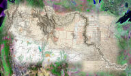
 The
U.S. Department of Agriculture's Natural Resources Conservation
Service (USDA-NRCS) has the responsibility for creating and maintaining
the Soil Survey Geographic (SSURGO) database. SSURGO provides important
baseline soils information for a wide range of agri-businesses,
from the producers (farmers and farm corporations) to the agricultural
input providers (ag chemicals and seed suppliers). Characteristics
such as soil texture, organic matter content, and drainage are key
factors in determining what crops are most suitable for certain
areas, as well as what are the appropriate types and application
rates for seed, fertilizer, herbicide, etc. Local branches of government
agencies involved in agricultural economics, extension services,
and environmental health (USDA, EPA, State/County DNR) also use
SSURGO to help determine what local management practices should
be encouraged for long term sustainable agriculture while minimizing
negative impacts on the environment. NRCS offices in six different
states currently use recent aerial photography and Telemorphic's
MapImager for ArcGIS to improve efficiency and reduce the costs
of creating and updating the SSURGO database.
The
U.S. Department of Agriculture's Natural Resources Conservation
Service (USDA-NRCS) has the responsibility for creating and maintaining
the Soil Survey Geographic (SSURGO) database. SSURGO provides important
baseline soils information for a wide range of agri-businesses,
from the producers (farmers and farm corporations) to the agricultural
input providers (ag chemicals and seed suppliers). Characteristics
such as soil texture, organic matter content, and drainage are key
factors in determining what crops are most suitable for certain
areas, as well as what are the appropriate types and application
rates for seed, fertilizer, herbicide, etc. Local branches of government
agencies involved in agricultural economics, extension services,
and environmental health (USDA, EPA, State/County DNR) also use
SSURGO to help determine what local management practices should
be encouraged for long term sustainable agriculture while minimizing
negative impacts on the environment. NRCS offices in six different
states currently use recent aerial photography and Telemorphic's
MapImager for ArcGIS to improve efficiency and reduce the costs
of creating and updating the SSURGO database.
On-Line Agricultural Information System for
Pixxures,
Inc. and Resource21, LLC.
 Pixxures,
Inc., a leading provider of on-line access to satellite imagery
and high resolution aerial photography archives, required a high
performance, easy-to-use web enabled application to support interactive
imagery analysis and GIS functionality as part of an on-line enterprise
agricultural information system (AgriTrax™ by Resource21). Telemorphic's
revolutionary Maplicity technology provided a very lightweight
(260kb) application that integrated seamlessly with Pixxures'
WebPix™ image delivery system, thereby providing instant on-line
access to nationwide high resolution imagery for agricultural
dealers (seed providers, ag chemical providers, corporate producers,
crop consultants, crop insurance adjusters) enabling them to quickly
and easily find and/or order imagery for customers' fields, draw/edit
field boundaries and exclusion areas based on the detailed imagery,
calculate accurate measurements of the fields, download/upload
GIS format data, print/save custom maps and reports, and even
conduct analysis of the site specific conditions within fields
based on crop vigor, nitrogen stress, soil moisture, and estimated
yield maps.
Pixxures,
Inc., a leading provider of on-line access to satellite imagery
and high resolution aerial photography archives, required a high
performance, easy-to-use web enabled application to support interactive
imagery analysis and GIS functionality as part of an on-line enterprise
agricultural information system (AgriTrax™ by Resource21). Telemorphic's
revolutionary Maplicity technology provided a very lightweight
(260kb) application that integrated seamlessly with Pixxures'
WebPix™ image delivery system, thereby providing instant on-line
access to nationwide high resolution imagery for agricultural
dealers (seed providers, ag chemical providers, corporate producers,
crop consultants, crop insurance adjusters) enabling them to quickly
and easily find and/or order imagery for customers' fields, draw/edit
field boundaries and exclusion areas based on the detailed imagery,
calculate accurate measurements of the fields, download/upload
GIS format data, print/save custom maps and reports, and even
conduct analysis of the site specific conditions within fields
based on crop vigor, nitrogen stress, soil moisture, and estimated
yield maps.
Forest Management for DuPage County, IL
 Effective
forest management in densely populated areas requires the capability
to rapidly create and disseminate maps, imagery, and management
plans between a number of interested parties including resource
managers, foresters, local government departments, and field crews.
The Forest Preserve District of DuPage County (FPDDC) uses Maplicity
as part of their regular forest management activities. Maplicity
enables FPDDC to distribute easy-to-use, yet powerful interactive
web mapping capabilities throughout the county. Maplicity bolted
right onto FPDDC's enterprise IT architecture to extend advanced
map tools including interactive graphics markup (redlining), custom
map creation, imagery change comparison, and many others to FPDDC
staff at a fraction of the cost of other solutions, and saving
FPDDC approximately 30 hours of staff labor each month.
Effective
forest management in densely populated areas requires the capability
to rapidly create and disseminate maps, imagery, and management
plans between a number of interested parties including resource
managers, foresters, local government departments, and field crews.
The Forest Preserve District of DuPage County (FPDDC) uses Maplicity
as part of their regular forest management activities. Maplicity
enables FPDDC to distribute easy-to-use, yet powerful interactive
web mapping capabilities throughout the county. Maplicity bolted
right onto FPDDC's enterprise IT architecture to extend advanced
map tools including interactive graphics markup (redlining), custom
map creation, imagery change comparison, and many others to FPDDC
staff at a fraction of the cost of other solutions, and saving
FPDDC approximately 30 hours of staff labor each month.